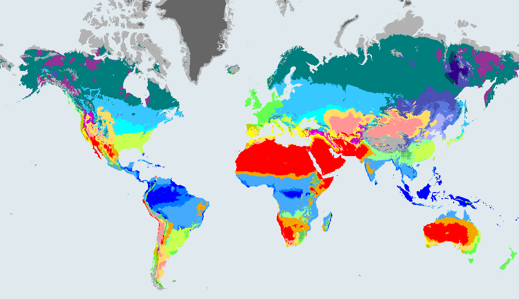
What a BSk climate is like
BSk Cold semi-arid (steppe). Steppe and prairie country. Too dry for forest, with big temperature swings between summer and winter in many places.
The rules behind the code, in plain English:
- Arid, but not dry enough to be a desert: yearly rainfall is between five and ten times the threshold.
- Cold: mean annual temperature below 18 °C.
Dataset wording: "Arid, steppe, cold". In the maps of Beck et al. (2023) the class is written: B: MAP < 10 x Pthreshold; S: MAP >= 5 x Pthreshold; k: MAT < 18.
Cold semi-arid climate (steppe) is dry grassland with cool or cold conditions, often far from the sea or in the rain shadow of mountains. Summers are warm and winters are chilly to cold, with low rainfall in most months. Wide grassy plains suit cattle and sheep, and wheat and barley are common where there is enough moisture. Buildings are made to hold heat in winter, and people dress in layers for big temperature swings.
How much of the world is BSk?
- 5.5%of the world's land outside Antarctica, 1991 to 2020
- 7,418,823 km²area, 1991 to 2020
- 1,182cities of 15,000 or more people (GeoNames) have this climate now
In 1901 to 1930 it covered 5.5% of that land, so its area then was 0.6% smaller than in 1991 to 2020.
How the BSk area is projected to change by 2071 to 2099
These figures compare the area of BSk in each future map with 1991 to 2020. They come from the Beck et al. (2023) model projections under three emissions scenarios. They show what the scenarios imply, not what will happen.
| Map | Share of land | Change in area vs 1991 to 2020 |
|---|---|---|
| 1901 to 1930 (past) | 5.5% | -0.6% |
| 1991 to 2020 (now) | 5.5% | - |
| 2071 to 2099, SSP1-2.6 (low emissions) | 5.2% | -4.93% |
| 2071 to 2099, SSP2-4.5 (middle of the road) | 5.1% | -7.31% |
| 2071 to 2099, SSP5-8.5 (high emissions) | 5% | -9.02% |
Shares are of land outside Antarctica. A negative change means the zone shrinks.
What happens to today's BSk land
Of the land that is BSk in 1991 to 2020, this is how much stays BSk and where the rest ends up in 2071 to 2099, by scenario:
| Scenario (2071 to 2099) | Stays BSk | Where the rest goes (biggest first) |
|---|---|---|
| SSP1-2.6, low emissions | 81% | BSh (9.5%), BWk (2.5%), Csa (1%), BWh (0.9%), ET (0.7%) |
| SSP2-4.5, middle of the road | 72% | BSh (17%), BWk (4.4%), BWh (2.6%), Csa (0.7%) |
| SSP5-8.5, high emissions | 55% | BSh (26%), BWk (9%), BWh (6.6%), Cwa (0.8%) |
Looking back, 81% of today's BSk land was also BSk in 1901 to 1930. The rest was BWk (3.7%), Dfb (2.6%), Dwa (1.8%), Dfa (1.7%), Dwc (1.7%).
Where BSk is found
The countries with the most BSk land in 1991 to 2020:
| Country | Area | Share of all BSk | Share of the country |
|---|---|---|---|
| United States | 1,620,855 km² | 22% | 17% |
| China | 1,047,723 km² | 14% | 11% |
| Kazakhstan | 956,614 km² | 13% | 35% |
| Argentina | 663,112 km² | 8.9% | 24% |
| Mongolia | 529,288 km² | 7.1% | 34% |
| Australia | 484,897 km² | 6.5% | 6.3% |
| Iran | 322,326 km² | 4.3% | 20% |
| South Africa | 271,298 km² | 3.7% | 22% |
Places with a BSk climate today
The biggest cities in the 1991 to 2020 map that sit in BSk (at most two per country):
Other arid climates (group B)
Frequently asked questions
What does BSk mean in the Köppen climate classification?
Arid, but not dry enough to be a desert: yearly rainfall is between five and ten times the threshold. Cold: mean annual temperature below 18 °C. The code is a short way of writing that: the first letter is the major group (B, arid) and the letters after it say more about rain and temperature.
What is a cold semi-arid (steppe) climate like?
Dry grassland with cool or cold conditions. Steppe and prairie country. Too dry for forest, with big temperature swings between summer and winter in many places.
How much of the world has a BSk climate?
5.5% of the world's land outside Antarctica was BSk in 1991 to 2020, about 7,418,823 km² (Beck et al. 2023, 1 km maps).
Will the BSk climate zone grow or shrink?
Under the middle-of-the-road scenario (SSP2-4.5), the area of BSk in 2071 to 2099 is 7.31% smaller than in 1991 to 2020. This is a model projection, not a forecast, and it differs under other scenarios (see the table on this page).
Data: Beck et al. (2023), CC BY 4.0. See data sources and licences. Köppen-Geiger classes describe long-term averages, not weather.